Extract Coordinate |
  
|
Extract Coordinate |
|
Standard Revit schedules cannot display data such as the XYZ coordinates of an element, or it's elevation relative to the level in which it appears.
The Extract Coordinates command will create extra parameters on an element that includes the coordinate or elevation data. These extra parameters can be used in standard Revit schedules, or used in conjunction with the ExcelLink.
The new parameters will contain values for:
•the element's project (local) xyz position
•the corresponding true (world) northing and easting.
•the top, center and bottom elevation of the 'bounding box' which encompasses that element.
These values are copied into the parameters exposed by that element, and then automatically kept up to date when the model is modified.
Note: If the model is modified in Revit without the CADtools Revit plugin installed, then the values will not be automatically kept up to date
Sample uses
•Creating Pile Schedules which include the setout information
•Tagging wall penetrations in plan to show the elevation of the penetration
Usage
Select the category of elements you want to extract the coordinates or elevations from.
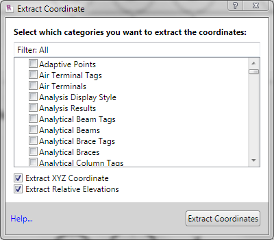
Extract XYZ Coordinates - Tick this option to create element parameters containing the local and world coordinates.
Extract Relative Elevations - Tick this option to create element parameters containing the elevation of the element relative to the level it appears in.
After the extraction completed, the elements will contains eight additional parameters that holds the coordinate data.
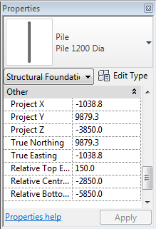
Project X, Y and Z - will be formatted according to the project units.
Northing & Easting - will be formatted according to the project units. (See Note 4)
Relative Elevations - will be formatted according to the project units.
Notes:
1. For elements which are sloping (e.g. pipework) the 'relative elevation' values will report the highest Z coordinate and the lowest Z coordinate of that element, which will most likely be at opposite ends of that element.
The 'relative elevations' tool is most useful for elements which are not sloping (e.g. wall penetrations, power outlets)
2.In order to keep this information up to date, CADtools Revit must be notified whenever any element is changed. Applying the 'Extract Coordinate' to many Revit element categories may have unintended performance consequences
3.The 'extracted' values are not a 'live' link to the XYZ coordinates or elevation. You cannot change those parameters to physically move the element.
4.From version 1.2.0.7 the Northing and Easting are reported in project units. Any existing projects will continue to be reported in Meters (which matches the behaviour prior to version 1.2)
Direct link to this topic:
© 2015 Arup